


Latest NewsOffshore ServicesMiros Introduces 3D Vessel View for Real-Time Wave Monitoring

Miros Introduces 3D Vessel View for Real-Time Wave Monitoring

Miros introduces a vessel-specific 3D visualisation to help operators interpret real-time wave measurements at critical offshore working locations

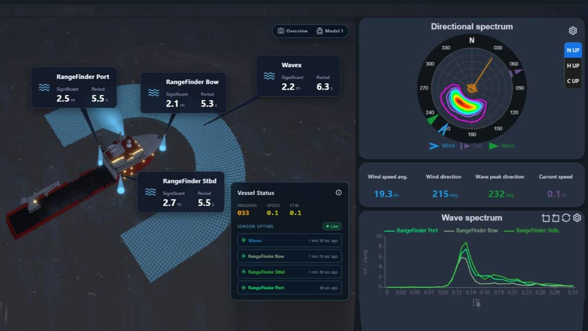
Norwegian ocean surface measurement specialist Miros has introduced a new 3D vessel view for its WaveSystem wave monitoring platform, giving crews and offshore operators a consolidated view of measured sea conditions around their vessel.

Designed to support weather-critical offshore operations, the new interface displays the location of each installed measurement source alongside its measurement area and key wave data. The bird’s-eye view enables crews to relate real-time sea state measurements to specific areas of the vessel and make more informed operational decisions.

The feature is included for WaveSystem subscribers worldwide at no additional cost.

Wave conditions can differ around a vessel due to wave direction, vessel heading, hull geometry, shielding, and measurement location. Where multiple measurement sources are installed, comparing readings can help teams clearly understand differences between measurement areas and sea conditions affecting specific working areas.

“A wave reading is more useful when the crew can see where it comes from and how it relates to the work,” said Aurelia Paraschiv, Product Manager at Miros. “The 3D vessel view brings that context into one display, helping teams compare measured conditions around the vessel and understand which readings matter to their operation.”

Bridge and deck crew can easily assess conditions port and starboard, check the waves at a specific working area such as a gangway or ROV launch point, and spot differences between measurement areas before they affect the operation, turning a weather-critical operation into a controlled one.

Marius Five Aarset, CEO at Miros, added: “The 3D vessel view automatically adapts to each vessel’s installed WaveSystem configuration, whether it carries two, three or more measurement sources. The data displayed reflects the equipment and accurate sea state measurement at its installation points on the vessel.” 

“We are committed and proud to support our customers in better identifying and understanding relevant, local sea conditions in real-time rather than having to rely on out-of-the-moment forecasts or hindcast assumptions.” 

The visualization shows measurement sources, areas, and values in relation to the vessel. It does not represent a reconstructed 3D sea surface.

Latest News

Auramarine has secured a contract with Spanish shipbuilder GONDAN Shipbuilders to supply complete methanol fuel supply systems for two new hydrographic research vessels, Wega and Deneb, being built for Germany’s Federal Maritime and Hydrographic Agency (Bundesamt für Seeschifffahrt und Hydrographie – BSH).

Auramarine Secures Dual Methanol Fuel System Order

The Finnish marine fuel systems specialist will supply complete methanol fuel supply systems for two GONDAN-built hydrographic research vessels being constructed for Germany’s BSH Auramarine...
Artemis Technologies has unveiled the next-generation Artemis EF-15 Escape, a fully electric foiling passenger vessel designed to accommodate up to 50 passengers, expanding the company's offering for urban and island waterborne transport, premium passenger services and logistics operations.

Artemis unveils 50-passenger electric foiling vessel

The next-generation fully electric foiling vessel features configurable passenger layouts and capacity for up to 50 passengers Artemis Technologies has unveiled the next-generation Artemis EF-15...
Combining GMDSS call statistics with an industry-first maritime safety broadcast analysis, Inmarsat Maritime’s new safety data platform aims to support shipping in addressing its persistent and evolving operational risks. Deep-sea shipping is an inherently hazardous enterprise and the many operational risks faced by vessels, cargo, and crew will likely never be eliminated entirely. Nevertheless, data can play a significant role in minimising the frequency and severity of incidents at sea.

Inmarsat Maritime Safety Data Hub Highlights Global Shipping Risks

Combining GMDSS call statistics with an industry-first maritime safety broadcast analysis, Inmarsat Maritime’s new safety data platform aims to support shipping in addressing its...
Bureau Veritas Marine & Offshore has awarded an Approval in Principle (AiP) to OceanAlpha for the design of its L42B uncrewed surface vessel (USV), developed for offshore hydrographic and geophysical survey operations.

OceanAlpha Secures BV AiP for L42B Offshore Survey USV

OceanAlpha's L42B combines a modular survey payload with remote operation capabilities to support extended offshore data-gathering missions Bureau Veritas Marine & Offshore (BV) has awarded...

Related news