Vaarst, a company advancing human and machine collaboration via highly accurate 3D, ML and data fusion, is introducing its world leading SubSLAM® X2 technology to the US market, following a strong year of activity across the UK, Europe and Africa.
The move continues the company’s global growth plans which saw it establish its first US base in 2022, to bring its expertise and capabilities in industrial robotics, computer vision, autonomy, and AI technologies to the Americas.
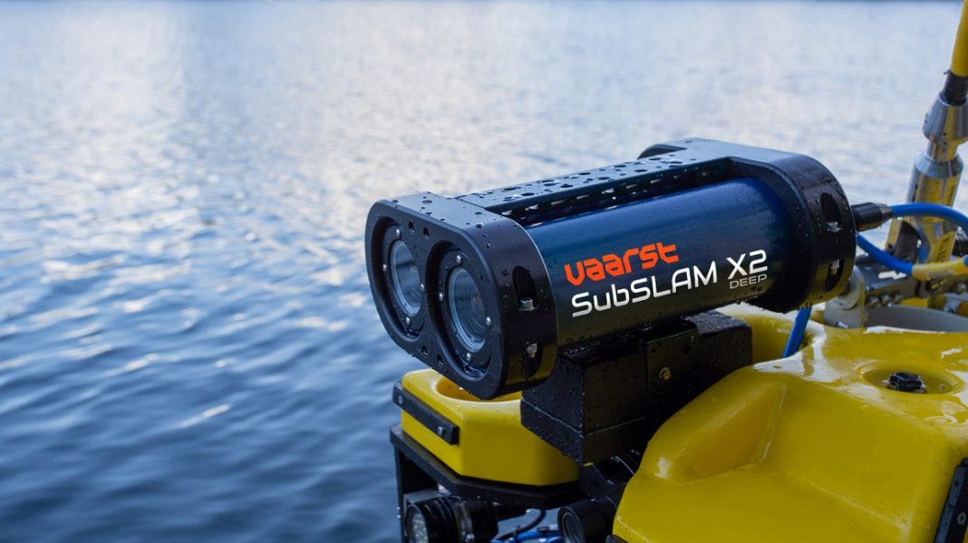
As an alternative to conventional video imagery and other 3D modelling systems that require scalebar deployment and post processing of results, SubSLAM® is the first real-time intelligent data collection system to deliver 4K resolution video with simultaneous high-quality live 3D dense point clouds at sub-millimetre accuracy. SubSLAM® has proven to be an industry game changer, allowing fast visualisation with even faster analysis and measurement of critical infrastructure and components, for asset owners operating across the subsea sectors of civils, marine sciences, offshore renewables and oil & gas.
Developed in the UK, SubSLAM® addresses many time-consuming disadvantages of conventional inspection procedures while delivering more detailed, quantifiable data faster than ever previously available. Applications across projects range from asset integrity, UWILD, subsea metrology for construction projects, decommissioning, pipeline inspection, cable pre-lay inspection, boulder removal, and coral reef inspections.
Five SubSLAM® systems are being introduced to the US, two deep water systems which can operate in depths down to 2000m/6562ft and three further systems which will operate in shallower waters down to 300m/984ft. A 6000m/19685ft capable system is expected to be available from Q3 2023.
The systems, which will make their debut off the US East Coast and in the Gulf of Mexico, are initially being made available to potential users such as operators, developers, drilling companies, service companies, universities engaged in marine science, and others on a trial or rental basis to give them the opportunity to test the capabilities of the system and to compare the results and benefits against more dated systems and ways of working. They will also be available for purchase on a licence or outright ownership basis.
Mitch Johnson, Director – Americas, said: “SubSLAM’s® industry-leading technology has been deployed very successfully in the North Sea, Baltic, Mediterranean and Gulf of Guinea. SubSLAM® enables asset owners to acquire, analyse, and operationalise data that helps them increase asset longevity and manage asset integrity with greater accuracy, speed, and cost-effectiveness.
“In response to growing interest on this side of the Atlantic, we are now making SubSLAM® more conveniently available to clients operating from the US. In addition to the measurable cost advantages it brings to clients, it is achieving significant environmental benefits by helping companies cut their carbon footprint by reducing vessel days, reducing offshore headcount and enabling faster offshore operations.“
Mounted on any ROV carrying out a visual inspection, SubSLAM® can record all data in a single flight, in a fraction of the time of other systems, negating the need for unnecessary additional mobilisations. Equipped with machine vision sensors and fast onboard processors, 3D reconstructions are modelled whilst high resolution 4K video footage is being captured.
Alternatively if work has to be carried out over a longer period of time, multi-session dives can be carried out, with SubSLAM’s® ability to recommence surveying at the exact point it left off.
With the ability to carry out real-time 3D inspections while gathering video footage in a single flight, SubSLAM takes away the need for the additional mobilisation of vessels, ROVs and personnel required with other systems. This delivers considerable time and cost savings while reducing the carbon footprint of end clients.
The 3D data can be streamed live to any device in the world to multiple recipients without the requirement for any special software on devices. Onshore engineers can remotely track progress, spot issues and react proactively, as the underwater survey is ongoing.
For further information, visit http://www.vaarst.com


