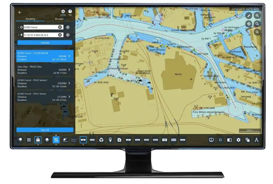
NAVTOR has launched what it believes to be a “transformational tool” for navigators, with the introduction of an advanced auto-routeing module to its NavStation digital chart table. This allows bridge officers, for the first time, to be able to calculate routes in a matter of seconds, and not just from port to port, but from “point to point.” The detailed routes, which can be refined for the exact needs of the vessels and voyages, are instantly available and can be seamlessly updated, compared and shared.
Johan Stensaker, Nautical Advisor, NAVTOR, says the development “hits a home run” for today’s busy navigators.
Meeting demand

“This is something that has been on the industry ‘wish-list’ for years… in fact we’ve been thinking about and developing this concept for almost a decade,” he reveals. “It is the first maritime auto-routeing application with this level of user-friendly functionality. It not only slashes the burden of administration, automating time-consuming tasks, but also allows navigators to easily pinpoint exact locations – of their vessels and the berths they want to reach – and block specific passages, port entries or straits as desired.
“Everything is done with a just a few clicks, in a matter of seconds, with all the critical data layers on NavStation ensuring complete compliance and control – both for vessels teams and, through our integrated e-Navigation ecosystem, on-shore management. This is big step forward, for NAVTOR, but also for our global customer base.”
Easy does it

The module, out now, works on the foundation of providing the shortest routes from port to port, waypoint to waypoint, current vessel location to ports, or from any given point to the huge majority of piers and berths in most major ports. Routes can be altered, or compared, at the touch at the button, with a myriad of options, such as adjusting for deep/shallow water routes and adding additional ports of call. All restricted areas, Traffic Separation Schemes (TSS), and other key criteria are taken into account.
NAVTOR CEO Tor Svanes, who has led the firm from a start-up in 2011 to the position where it is now the world’s leading supplier of ENCs (with products and services on over 8000 vessels), describes the development as “one of the most important innovations” his team has worked on.
Day-to-day difference
He comments: “It has always been our mission to understand industry challenges and provide solutions, making life simpler, safer and more efficient for users and shipping businesses. Auto-Routeing on NavStation ticks all the boxes. It is an easy-to-use, comprehensive, flexible, day-to-day tool that, we believe, is a ‘line in the sand’ in terms of how officers plan, decide upon and execute routes. I’ll be excited to see how the industry reacts to a solution that navigators have really been crying out for. We’re delighted to be the ones delivering it.”
The Auto-Routeing module is available as a subscription service on NavStation, alongside other ‘layers’ including port data, AMVER reporting, weather routing, manoeuvring assistant, passage planning, e-publication reader, environmental regulations and much more.


